Centralized booking system for CAI huts

The Italian Alpine Club (CAI) has recently inaugurated a centralized online booking system for all huts owned by the club. The new system makes the booking of stays easier, especially for people that do not speak Italian.

In Abruzzo there are four CAI owned huts:

The new booking systems is active from the Summer of 2024.

Closure of Bivacco Bafile

The Bivacco Bafile (Bafile Bivouac) is an emergency shelter on the south-east ridge of the central summit of Corno Grande (Gran Sasso range). It is located at 2669 meters / 8756 feet above sea level and is accessible from Campo Imperatore via a hiking trail and a ferrata. Built in 1966 by the L’Aquila section of the Italian Alpine Club (CAI), it provides both emergency shelter from bad weather, and easy access to various climbing routes on the south face of Corno Grande. It is also very popular with hikers (equipped with harness, helmet, a ferrata kit, and no fear for exposure) who want to spend the night at altitude and see the sun rise over the Adriatic sea in the morning.

After 58 years in service, the bivouac was badly damaged by a storm during the 2023/2024 winter, and the CAI section of L’Aquila declared [1] that the structure is not safe anymore, and should not be used during the current season.

The good news is that they already got the funding for a new bivouac, that will be placed in the spot of the old one during the summer of 2025, while the old structure will be removed in the fall of 2024, repaired, and it will find a new home in the city of L’Aquila.

[1] https://cailaquila.it/inagibilita-del-bivacco-andrea-bafile/

Sentiero del Centenario: closed

As you may remember, in February 2024 the L’Aquila chapter of the Italian Alpine Club (CAI) upgraded the rating of the Centenario trail from a hike to an alpine route, due to the conditions of the equipped sections of the trail.

Unfortunately, on the 29th of May of this year the municipality of L’Aquila announced the immediate closure of the trail with an executive order; you can find the order here (in Italian). While the order only covers the section of the trail that is located in the territory of L’Aquila, the other municipalities that are crossed by the trail also published similar orders.

Therefore, the Centenario trail must be considered closed, and considering the time it may take to fix all the equipped sections, this situation may last for years. A sad day for our beloved region.

Issues on the Centenario trail

The Centenario trail is one of the most iconic trails of the Gran Sasso massif. It starts from Vado di Corno and ends in Fonte Vetica, going through most of the west ridge of the massif, reaching the top of Brancastello, Torri di Casanova, Infornace, Prena, and Camicia. The trail is around 17 kilometers / 10.5 miles long with more than 1700 meters / 5577 feet of ascent. There is also a Strava Segment of the trail.

On the Italian rating scale for trails it is usually marked as EEA: meaning only experienced hikers with the right equipment should attempt it. The reason is that some sections of the ridge, in particular from the Torri di Casanova to the summit of Monte Camicia, require some scrambling or are equipped with ladders and steel cables.

On the 22nd of February 2024 the Italian Alpine Club (CAI) section of L’Aquila published a notice [1] (in Italian) saying that, because of the poor conditions of some of the equipped sections of the trail, the Centenario should not be considered anymore a hike but an alpine route, and therefore should be attempted only by people with alpine experience and the right equipment.

[1] https://cailaquila.it/avviso-sentiero-del-centenario/

Campo Imperatore

Cammino del Gran Sasso

Announced in February 2023, the “Cammino del Gran Sasso” is the latest addition to the collection of long distance hiking trails in Abruzzo.

The trail is officially divided into five stages:
1) Campo Imperatore to Castel del Monte
2) Castel del Monte to Rocca Calascio
3) Rocca Calascio to Santo Stefano di Sessanio
4) Santo Stefano di Sessanio to Barisciano
5) Barisciano to Fonte Cerreto

The total distance of this trail is around 60 km / 37 miles and it is a downhill dominated trail, meaning that in total there is more downhill than uphill. To be more precise, the total ascent of the trail is 2306 meters / 7565 feet, and the total descent 3296 meters / 10813 feet. So better prepare your legs for descents before attempting it.

Although the trail is officially divided into five stages, almost two thirds of the total distance are covered in stages 1 and 5, and the remaining three stages could be combined by more time constrained hikers. All starting and ending points have hotels and other lodging available, but it may be required to book your stay in advance, especially during high season.

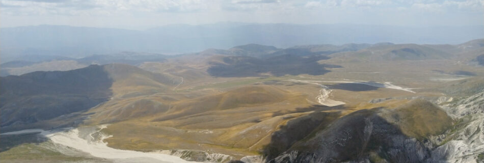
Overall, this trail seems to offer plenty of scenic views, including mountains, canyons, castles, and villages from the middle age, but without crossing high alpine terrain, and therefore should be possible to hike it from spring to autumn most years. The official website (linked below) offers various information on how to plan your trip, including tracks in KMZ format. You may want to convert the tracks into GPX before loading them into your watch for navigation.

Official website: camminodelgransasso.it